| Name
|
Remains
|
Date
|
Location
|
Description
|
Ref(s)[A]
|
Round cairn
(nr. Old Harper's Farm)
|
Cairn
|
Bronze Age
|
Horwich 53°36′25″N 2°30′39″W / 53.6070°N 2.5107°W / 53.6070; -2.5107 (Round cairn on Winter Hill)
|
On the eastern slope of Adam Hill, in the Winter Hill massif, a round cairn on a local high point 280 metres (920 ft) west of Old Harpers Farm. It is a slightly oval mound of stones, covered with turf, measuring approximately 12 m (39 ft) by 11.5 m (38 ft) and standing 0.4 m (1 ft 4 in) high. The cairn is unexcavated and retains undisturbed deposits of archaeological value.
|
[12]
|
| Stone circle, ring cairn and two round cairns
|
Cairns
|
Bronze Age
|
Egerton 53°38′20″N 2°25′49″W / 53.6388°N 2.4303°W / 53.6388; -2.4303
|
A prehistoric complex comprising a damaged stone circle, a ring cairn, and two round cairns. The site lies on a high ridge above Bromley Cross, close to the boundary with Lancashire, and preserves significant archaeological remains despite historic disturbance.
|
[13]
|
| Moated site at Arley Hall
|
Moat
|
0113th–14th century
|
Blackrod 53°35′27″N 2°37′17″W / 53.5909°N 2.6214°W / 53.5909; -2.6214 (Arley Hall)
|
A well‑preserved medieval moated site consisting of a near‑circular, water‑filled moat enclosing a central platform occupied by a later house. The moat survives to substantial width with stone‑revetted banks, and access is provided by a 19th‑century iron bridge.
|
[14]
|
| Smithills Hall
|
Standing building
|
0114th century
|
Bolton 53°36′08″N 2°27′15″W / 53.6023°N 2.4542°W / 53.6023; -2.4542 (Smithills Hall)
|
Originally built in the early 14th century, but was extended in the 15th and 16th centuries. The oldest surviving part is the great hall, which dates from the early 15th century. The site was originally moated; however, no trace of the moat survives. Smithills Hall is now a Grade I listed building and is open to the public as a museum.
|
[15][16]
|
| Ringley Old Bridge
|
Stone bridge
|
021677
|
Stoneclough, Kearsley 53°32′37″N 2°21′26″W / 53.5437°N 2.3573°W / 53.5437; -2.3573 (Ringley Old Bridge)
|
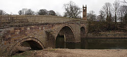
The current bridge over the River Irwell was built in 1677 to replace one that was washed away in 1673. It is still in use today, having been pedestrianised, and is a Grade II* listed building.
|
[17][18][19]
|
| Chequerbent embankment
|
Railway embankment
|
02c. 1828
|
Westhoughton 53°33′02″N 2°29′40″W / 53.5505°N 2.4944°W / 53.5505; -2.4944 (Chequerbent)
|
A surviving section of the Bolton and Leigh Railway, located between the A6 Manchester Road and the M61 motorway, approximately 200 m (660 ft) east of the A58, and preserved as an earth embankment with a raised stone‑built track bed.
|
[20]
|
| Name
|
Remains
|
Date
|
Location
|
Description
|
Ref(s)[A]
|
| Mamucium
|
Below ground remains
|
0079
|
Castlefield 53°28′29″N 2°15′12″W / 53.4747°N 2.2532°W / 53.4747; -2.2532 (Mamucium)
|
A Roman fort was established on a sandstone bluff near a crossing of the River Medlock, along the line of the Roman road between Chester (Deva Victrix) and York (Eboracum). It was designed to garrison a cohort of 500 auxiliary soldiers, and a civilian settlement (vicus) of traders and families developed around it. Around 140, the fort was demolished and the settlement was abandoned at roughly the same time. The fort was rebuilt in 160 and the settlement re-inhabited. It was abandoned by the mid-3rd century, although the fort remained in use into the early 4th century. A partial reconstruction of the fort on the site is open to the public.
|
[27][28][29][30]
|
| Nico Ditch[B]
|
Earthwork
|
017th–9th centuries
|
Ashton-under-Lyne and Denton 53°27′11″N 2°24′00″W / 53.4531°N 2.3999°W / 53.4531; -2.3999 (Nico Ditch)
|
An earthwork stretching from Ashton Moss in the east to Hough Moss in the west. According to legend, it was dug in a single night as a defence against Viking invaders in 869–870. However, its U-shaped profile suggests it was not defensive, as a true defensive ditch would more likely be V-shaped. It was probably used as an administrative boundary. The ditch is visible in sections and, in places, is about 1.5 m (4.9 ft) deep and up to 4 m (13 ft) wide.
|
[31][32][33]
|
| Baguley Hall
|
Standing building
|
0214th century
|
Baguley 53°23′42″N 2°16′35″W / 53.3950°N 2.2764°W / 53.3950; -2.2764 (Baguley Hall)
|
The original building may date from the 11th or 12th century, but the current timber-framed house is from the 14th century. The medieval north wing was refaced in brick, and the brick south wing was added in the 18th century. It is considered one of the "finest surviving medieval halls in the northwest of England". It is a Grade I listed building, and is on the Buildings at Risk Register; its condition is rated as "poor" and it is owned by Heritage Trust for the North West.
|
[34][35][36][37]
|
| Peel Hall
|
Waterlogged moat
|
0314th century
|
Ashton New Road, Manchester 53°22′41″N 2°14′39″W / 53.3780°N 2.2443°W / 53.3780; -2.2443 (Peel Hall)
|
In the mid-14th century, Sir John de Arderne built Peel Hall. The site is surrounded by a moat between 8 and 14 m (26 and 46 ft) wide and 1.2 m (3.9 ft) deep. Peel Hall was demolished in 1809 and replaced by a farmhouse on the same site, which was itself demolished in 1975.
|
[38][39]
|
| Hanging Bridge
|
Ruins
|
051421
|
Cateaton Street, Manchester 53°29′04″N 2°14′36″W / 53.4845°N 2.2433°W / 53.4845; -2.2433 (Hanging Bridge)
|
The current structure was built in 1421; however, the first reference to the bridge dates from 1343. The bridge, which is 33 m (108 ft) long and 2.7 m (8.9 ft) wide, spanned Hanging Ditch and formed part of medieval Manchester's defences. Hanging Bridge was probably obscured by housing in the 1770s as a result of Manchester's expansion. It was uncovered in the 1880s, and again in the late 20th century, and is now on display in Manchester Cathedral's visitor centre.
|
[40][41][42][43]
|
| Clayton Hall
|
Standing building
|
0415th century
|
Clayton 53°29′00″N 2°10′43″W / 53.4834°N 2.1787°W / 53.4834; -2.1787 (Clayton Hall)
|
The hall, which probably dates back to the 15th century, was originally either a quadrangle or a three-winged structure. Much of it was demolished in the 17th century and replaced by a new house. Clayton Hall underwent further alterations and restoration in the 18th century and again in 1900. It stands on a rectangular island surrounded by a moat and is a Grade II* listed building.
|
[44][45][46]
|
| Name
|
Remains
|
Date
|
Location
|
Description
|
Ref(s)[A]
|
| Saddleworth Bowl Barrow
|
Earthworks
|
00Bronze Age
|
Saddleworth 53°33′49″N 2°01′48″W / 53.5636°N 2.0300°W / 53.5636; -2.0300 (Saddleworth Bowl Barrow)
|
The barrow is oval-shaped and measures 17 m (56 ft) by 18 m (59 ft), with a height of 0.5 m (1.6 ft). It has been archaeologically excavated, but no grave goods or human remains were found. The site is in good condition.
|
[47][48]
|
| Castleshaw Roman fort
|
Below ground remains
|
0179
|
Castleshaw, Saddleworth 53°35′00″N 2°00′06″W / 53.5832°N 2.0017°W / 53.5832; -2.0017 (Castleshaw Roman fort)
|
In 79, a Roman fort was established at Castleshaw to house a garrison of 500 auxiliary soldiers, forming part of the frontier defences along the road between Chester (Deva Victrix) and York (Eboracum). It was slighted in 90, but a smaller fort—or fortlet—was built on the site in 105, designed for a garrison of fewer than 100. A civilian settlement (vicus), made up of traders and hangers-on associated with the soldiers, developed around the fort in the 2nd century. The fortlet was abandoned in the mid-120s when it was superseded by the neighbouring forts at Manchester and Slack. About the same time, the civilian settlement was also abandoned. A series of ditches and earthworks was constructed to mark the site.
|
[49][50][51][52][53][54]
|
| Name
|
Remains
|
Date
|
Location
|
Description
|
Ref(s)[A]
|
| Brown Low
|
Earthworks
|
00Bronze Age
|
Ludworth, Hazel Grove 53°24′54″N 2°01′04″W / 53.4149°N 2.0177°W / 53.4149; -2.0177 (Brown Low)
|
A bowl barrow measuring 25.5 m (84 ft) in diameter and 2 m (6.6 ft) in height. The mound is grass-covered, and two visible hollows on its surface mark the site of an excavation carried out in 1809.
|
[66][67]
|
| Cairn
|
Mound of stones
|
01Bronze Age
|
Ludworth, Hazel Grove 53°22′55″N 2°01′13″W / 53.3819°N 2.0202°W / 53.3819; -2.0202 (Ludworth cairn)
|
The late Bronze Age cairn measures 12 m (39 ft) in diameter and 0.4 m (1.3 ft) in height. It contains a series of chambers and cremation cists. Positioned on a knoll on Mellor Moor, the cairn is prominently sited and highly visible in the surrounding landscape.
|
[68][69]
|
| Peel Moat
|
Dry moat
|
02Medieval
|
Heaton Moor 53°25′43″N 2°11′18″W / 53.4287°N 2.1884°W / 53.4287; -2.1884 (Peel Moat)
|
The dried-up rectangular moat surrounds the site of a square-shaped fortified tower. There are no above-ground remains of the tower, but it stood on a plot of land measuring 29 m (95 ft) square, with the moat around it ranging from 5.5 m (18 ft) to 10 m (33 ft) in width.
|
[70][71]
|
| Torkington Moat
|
Water-logged moat
|
03Medieval
|
Torkington 53°23′06″N 2°05′28″W / 53.3849°N 2.0910°W / 53.3849; -2.0910 (Torkington Moat)
|
The moat surrounds the site of the manor house first built in 1350. It is 1.6 m (5.2 ft) deep, between 8 and 20 m (26 and 66 ft) wide, and encloses an island measuring 46 m (151 ft) by 43 m (141 ft). Torkington Hall replaced the medieval manor house in the early 17th century.
|
[72][73]
|
| Oldknow's Limekilns
|
Lime kilns
|
041797
|
Marple 53°23′34″N 2°03′21″W / 53.3927°N 2.0557°W / 53.3927; -2.0557 (Oldknow Limekilns)
|
Between 1797 and 1800, Samuel Oldknow built three lime kilns on the east side of the Peak Forest Canal. The kilns are 11 m (36 ft) deep and were constructed into the hillside. The site remained in use into the 20th century, and the surviving kiln walling is now protected as a Grade II listed building.
|
[10][74][75]
|
| Marple Aqueduct
|
Aqueduct
|
051801
|
Marple 53°24′25″N 2°04′02″W / 53.4070°N 2.0673°W / 53.4070; -2.0673 (Marple Aqueduct)
|
The aqueduct was built between 1794 and 1801 to carry the Peak Forest Canal over the River Goyt. It remains in use today, carrying pleasure craft along the canal and forming one of the most prominent engineering features of the route.
|
[9][76]
|
| Name
|
Remains
|
Date
|
Location
|
Description
|
Ref(s)[A]
|
| Cairn
|
Mound of stones
|
00Bronze Age
|
Stalybridge 53°28′44″N 2°01′06″W / 53.4788°N 2.0184°W / 53.4788; -2.0184 (Stalybridge Cairn)
|
The turf covered round cairn is situated on top of a hill, and consists of a mound of stones with a flat top. It is 1 m (3.3 ft) tall and 16 m (52 ft) in diameter, although the southern edge has been destroyed. The site has been altered in modern period by the addition of a dry stone wall and a trigonometrical pillar.
|
[77][78]
|
| Nico Ditch[B]
|
Earthwork
|
015th–11th centuries
|
Denton 53°27′40″N 2°08′43″W / 53.4611°N 2.1454°W / 53.4611; -2.1454 (Nico Ditch)
|
A surviving section of the early medieval ditch, a linear earthwork running east–west across Greater Manchester. At this point on Denton Golf Course, the ditch survives as a well‑preserved earthwork defined by a shallow linear depression representing part of a boundary feature dug between the 5th and 11th centuries. This section is protected for its archaeological value as one of the few intact stretches of the ditch, which elsewhere has been largely levelled by later development.
|
[79]
|
| Buckton Castle
|
Below ground remains
|
011180s
|
Carrbrook 53°30′40″N 2°00′58″W / 53.5111°N 2.0162°W / 53.5111; -2.0162 (Buckton Castle)
|
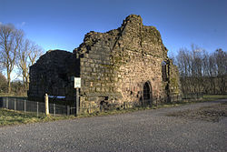
An enclosure castle, probably built by the earls of Chester in the 12th century. It may have been constructed to guard the Longdendale Valley. The castle was first recorded in 1360, when it was already in a ruinous state. It is circular in form, measuring 35 m (115 ft) and 45 m (148 ft) along its axes, and is surrounded by a ditch 10 m (33 ft) wide and 6 m (20 ft) deep. The castle has been damaged by 18th-century treasure hunters and by quarrying in the 19th and 20th centuries.
|
[4][80][81][82][83]
|
| Post-medieval glassworks
|
Below ground remains
|
011612
|
Denton 53°26′55″N 2°05′23″W / 53.4485°N 2.0896°W / 53.4485; -2.0896 (Post-medieval glassworks)
|
A post‑medieval glassworks located 250 m (820 ft) south‑east of Clarke's Bridge, consisting of the remains of furnace bases and other structures associated with glass production. The site preserves evidence of small‑scale industrial activity and the layout of a rural glassmaking operation.
|
[84]
|
| Name
|
Remains
|
Date
|
Location
|
Description
|
Ref(s)[A]
|
| Cross base
|
Cross base
|
aMedieval
|
Junction of Green Lane, Standish Wood Lane and Beech Walk, Standish 53°34′49″N 2°39′43″W / 53.5803°N 2.6620°W / 53.5803; -2.6620 (Cross base)
|
One of four documented wayside crosses that delineated the medieval route between Wigan and Chorley. Serving both as navigational markers and as points of devotional significance, these crosses formed part of a wider network of route indicators across the region. The surviving base at this junction is no longer in its original position; it was relocated from its historic site when the road layout was altered and widened.
|
[87][88]
|
| Cross base
|
Cross base
|
bMedieval
|
Green Lane, Standish 53°34′52″N 2°39′38″W / 53.5811°N 2.6605°W / 53.5811; -2.6605 (Cross base)
|
One of four documented wayside crosses that delineated the medieval route between Wigan and Chorley. It stands on Green Lane approximately 300 metres (980 ft) to the north of Strickland House Farm and is protected as a Grade II listed building.
|
[89][90][91]
|
| Cross base
|
Cross base
|
cMedieval
|
Standish Wood Lane, Standish 53°34′25″N 2°39′38″W / 53.5735°N 2.6605°W / 53.5735; -2.6605 (Cross base)
|
One of four documented wayside crosses that delineated the medieval route between Wigan and Chorley. It is located approximately 700 metres (2,300 ft) south‑east of Standish Hall.
|
[92][93]
|
| Morleys Hall moated site
|
Standing building and moat
|
eMedieval
|
Astley 53°29′20″N 2°28′04″W / 53.4890°N 2.4678°W / 53.4890; -2.4678 (Morleys Hall)
|
A moated site centred on Morleys Hall, a 19th‑century house that incorporates substantial 16th and 17th‑century timber framing and was the home of Ambrose Barlow in 1641. The complex is enclosed by a broad, waterlogged medieval moat measuring approximately 12–15 m (39–49 ft) in width and around 3 m (9.8 ft) in depth. Morleys Hall is a Grade II* listed building.
|
[94][95][96]
|
| Standish Market Cross
|
Stone cross
|
dMedieval
|
Market Place, Standish 53°35′11″N 2°39′38″W / 53.5865°N 2.6606°W / 53.5865; -2.6606 (Standish Market Cross)
|
The cross stands in the marketplace west of St Wilfrid's Church, its substantial stone base dating from the medieval period, while the present cross shaft is a later, modern replacement. The structure remains an important focal point within the historic village centre and is protected as a Grade II listed building.
|
[97][98][99]
|
| Mab's Cross
|
Stub of stone cross
|
f13th century
|
Standishgate, Wigan 53°33′04″N 2°37′34″W / 53.5511°N 2.6261°W / 53.5511; -2.6261 (Mab's Cross)
|
One of four documented wayside crosses that delineated the medieval route between Wigan and Chorley. In 1922 the cross was moved from its original position when the road was widened and is protected as a Grade II* listed building.
|
[100][101][102]
|
| New Hall moated site
|
Moat
|
g16th century
|
Astley, Tyldesley 53°30′21″N 2°27′12″W / 53.5057°N 2.4534°W / 53.5057; -2.4534 (New Hall)
|
The moat encloses the site of the original medieval building, which was later replaced by a post‑medieval farmhouse. Although the moat remains water‑filled and well‑preserved, the ruined farmhouse itself lies outside the extent of the scheduled monument.
|
[103][104]
|
| Winstanley Hall moated site
|
Standing building and moat
|
h1560s
|
Winstanley 53°31′21″N 2°41′15″W / 53.5224°N 2.6874°W / 53.5224; -2.6874 (Winstanley Hall)
|
Built in the 1560s for the Winstanley family of Wigan, Lords of the Manor, the hall is linked with neighbouring estates such as Bispham Hall (1573), Birchley Hall (1594), and Hacking Hall (1607). It was enlarged in the 17th and 18th centuries, with further 19th-century Jacobean-style alterations by Lewis Wyatt. The manorial complex includes a moated site with a rectangular island of about 50 m (160 ft) by 40 m (130 ft), enclosed on three sides by a waterlogged medieval moat up to 15 m (49 ft) wide and around 1 m (3 ft 3 in) deep, along with former fish ponds. The hall now stands decayed and unoccupied, and is designated as a Grade II* listed building.
|
[105][106][107][108][109]
|
| Gidlow Hall moated site
|
Standing building and moat
|
h1574
|
Aspull 53°33′31″N 2°33′59″W / 53.5585°N 2.5664°W / 53.5585; -2.5664 (Gidlow Hall)
|
The present structure dates from around 1574, although it is thought to have replaced an earlier building. In 1840 the hall was rebuilt in the Gothic Revival style. The associated moated site is sub‑rectangular, with maximum dimensions of about 105 m (344 ft) north‑west to south‑east and 75 m (246 ft) north‑east to south‑west. Its water‑filled moat averages 9 m (30 ft) in width and appears to be at least 1.5 m (4 ft 11 in) deep. The hall is designated as a Grade II listed building.
|
[110][111][112]
|
| The Great Haigh Sough portal
|
Brick drainage
|
i1653
|
Haigh 53°33′33″N 2°37′03″W / 53.5591°N 2.6174°W / 53.5591; -2.6174 (Haigh Sough drainage)
|
Between 1653 and 1670, the Haigh Sough drainage system was constructed to drain the local collieries. The system extends for 936 m (3,071 ft) and has only a single entrance. It remained in use until 1929, and the entrance is now covered by a steel grille to prevent access.
|
[113][114]
|
| Moat House moated site
|
Dried-up moat
|
j18th century
|
Haigh 53°34′36″N 2°36′13″W / 53.5766°N 2.6036°W / 53.5766; -2.6036 (Moat House)
|
A medieval moated site comprising a square, dry moat preserved as a garden feature. Each side measures approximately 50 m (160 ft) externally, with stone‑lined edges to a depth of about 0.75 m (2 ft 6 in). The moat averages 1.5 m (4 ft 11 in) in depth and around 8 m (26 ft) in width, enclosing the site of Moat House, a Grade II listed building.
|
[115][116]
|
| Astley Green Colliery
|
Mining site
|
k1908
|
Astley 53°29′43″N 2°26′41″W / 53.4953°N 2.4446°W / 53.4953; -2.4446 (Astley Green Colliery)
|
The Pilkington Colliery Company began construction of the colliery in 1908, and the site opened for coal production in 1912. The colliery closed in 1970 and is now Astley Green Colliery Museum. Most of the buildings associated with the site have been demolished, as has one of the mine shafts.
|
[3][117]
|
|
 Ringley Old Bridge in Ringley Ringley Old Bridge in Ringley
 Affetside Cross replaced an earlier medieval cross Affetside Cross replaced an earlier medieval cross
 The standing remains of Radcliffe Tower The standing remains of Radcliffe Tower
 The 14th-century Baguley Hall, in Baguley is also a Grade I listed building The 14th-century Baguley Hall, in Baguley is also a Grade I listed building
 Clayton Hall, in Clayton is also a Grade II* listed building Clayton Hall, in Clayton is also a Grade II* listed building
 A reconstructed section of the wall of Mamucium fort A reconstructed section of the wall of Mamucium fort
 Hanging Bridge was excavated in 1892 Hanging Bridge was excavated in 1892
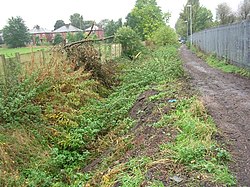 Looking west along Nico Ditch, near Levenshulme Looking west along Nico Ditch, near Levenshulme
 A plan of Castleshaw drawn by Thomas Percival in 1752 showing the fort and the later fortlet A plan of Castleshaw drawn by Thomas Percival in 1752 showing the fort and the later fortlet
 Worsley Delph Worsley Delph
 The Marple Aqueduct crossing the River Goyt The Marple Aqueduct crossing the River Goyt
 View of Buckton Castle from below View of Buckton Castle from below
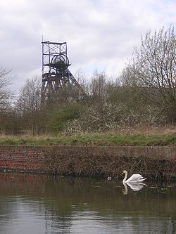 Astley Green Colliery's pithead, viewed from across the Bridgewater Canal Astley Green Colliery's pithead, viewed from across the Bridgewater Canal
 Winstanley Hall, a Tudor house, is also a Grade II* listed building Winstanley Hall, a Tudor house, is also a Grade II* listed building
 Mab's Cross is a Grade II* listed building Mab's Cross is a Grade II* listed building
|
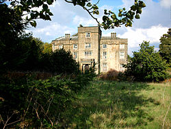
 Smithills Hall is one of several medieval manor houses in Greater Manchester to be protected as a scheduled monument
 Ringley Old Bridge in Ringley
 Affetside Cross replaced an earlier medieval cross
 The standing remains of Radcliffe Tower
 The 14th-century Baguley Hall, in Baguley is also a Grade I listed building
 Clayton Hall, in Clayton is also a Grade II* listed building
 A reconstructed section of the wall of Mamucium fort
 Hanging Bridge was excavated in 1892
 Looking west along Nico Ditch, near Levenshulme
 A plan of Castleshaw drawn by Thomas Percival in 1752 showing the fort and the later fortlet
 Worsley Delph
 The Marple Aqueduct crossing the River Goyt
 View of Buckton Castle from below
 Astley Green Colliery's pithead, viewed from across the Bridgewater Canal
 Winstanley Hall, a Tudor house, is also a Grade II* listed building
 Mab's Cross is a Grade II* listed building