You can help expand this article with text translated from the corresponding article in Indonesian. (October 2023) Click [show] for important translation instructions.
|
Samarinda | |
|---|---|
| City of Samarinda Kota Samarinda | |
Clockwise, from top: Samarinda Islamic Center seen from the Mahakam River, Samarinda Regional House of Representatives building, Samarinda Museum, East Kalimantan Regional House of Representatives building, East Kalimantan Governor Residence | |
 Flag  Coat of arms | |
| Motto: Samarinda Kota Tepian | |
| Anthem: "March of Kota Tepian" | |
 Location within East Kalimantan | |
 Samarinda Location in Borneo | |
| Coordinates: 0°30′00″S 117°08′16″E / 0.50000°S 117.13778°E | |
| Country | |
| Province | |
| Founded | 1668 |
| Government | |
| • Mayor | Andi Harun (Gerindra) |
| • Vice Mayor | Saefuddin Zuhri |
| • Legislature | Samarinda City Regional House of Representatives |
| Area | |
• City | 718 km2 (277 sq mi) |
| • Land | 691.53 km2 (267.00 sq mi) |
| • Water | 26.47 km2 (10.22 sq mi) 3.65% |
| • Rank | 7th (Indonesia)[2] |
| Highest elevation | 260 m (850 ft) |
| Lowest elevation | 0 m (0 ft) |
| Population (mid 2024 estimate)[1] | |
• City | |
| • Rank | 1st (Borneo)[7] |
| • Density | 1,163/km2 (3,010/sq mi) |
| • Metro | 1,050,000 |
| Demonym | Samarindan[8] |
| Demographics | |
| • Religion[9] | Islam 91.28% Protestantism 5.08% Catholic 2.60% Buddhism 0.91% Hinduism 0.09% Confucianism 0.03% Others 0.01% |
| Time zone | UTC+08:00 (WITA) |
| Postal code | 75000 |
| Area code | +62541 |
| Administrative centre | Bugis[10] |
| Largest district by population | Sungai Kunjang[1] |
| Date format | dd-mm-yyyy |
| Drives on the | left |
| HDI (2022) | |


Samarinda is the capital city of the Indonesian province of East Kalimantan on the island of Borneo. The city lies on the banks of the Mahakam River with a land area of 718 km2 (277 sq mi). Samarinda was one of Indonesia's top ten Most Liveable Cities in 2022,[11][12] ranks first on East Kalimantan Human Development Index[13] and it is the most populous city on the entire Borneo island, with a population of 727,500 at the 2010 Census[14] and 827,994 at the 2020 Census;[15] the official estimate as at mid 2024 was 868,499.[1] Samarinda is East Kalimantan's largest exporter[16] and fifth-largest importer.[17] The city has the highest number of bank headquarters in East Kalimantan.[18]
Samarinda was formally established as a city on 26 June 1959, after being separated from the outgoing Special Region of Kutai, a second-level administrative division similar to a regency that was ruled by the eponymous sultanate.[19] Before becoming the capital city of East Kalimantan, it was the seat of Special Region of Kutai during its early years until it was moved into Tenggarong in 1956.[20]
In 2021, Samarinda Harbour became the busiest passenger port in East Kalimantan.[21] The container port in Samarinda is also the busiest in East Kalimantan, handled more than 271 thousand twenty-foot equivalent units (TEU) in 2019.[22][23] Samarinda is known for its traditional food amplang, as well as the cloth sarung samarinda.[24] As of 2021, the city has 3 bridges connecting its riverbanks: Mahakam Bridge, Mahakam Ulu Bridge, and Achmad Amins Bridge. The city centre is located north of the Mahakam river.
Etymology
[edit]The name Samarinda originates from the description of the way in which the Bugis houses were constructed. At that time houses were customarily built on a raft and generally had the same height. This provided important social symbolism of equality between residents; no person's house, and thus no person, was seen as higher or lower than another. They named the settlement “Samarenda”, meaning “equally low”. After hundreds of years of use the pronunciation of the name changed slightly and the city became known as Samarinda.[25]
History
[edit]Samarinda was known as one of the territories in Kutai Kertanegara ing Martapura Sultanate. In the 13th century, before known as Samarinda, it already had villages settled in 6 locations.
At the start of the Gowa War, the Dutch under Admiral Speelman's command attacked Makassar from the sea. Meanwhile, the Netherlands' Bugis ally Arung Palakka led a ground attack. The Kingdom of Gowa was forced to surrender and Sultan Hasanuddin was made to sign the Treaty of Bongaja on 19 November 1667.[26]
The treaty did not quell all trouble for the Dutch however, since the Bugis from Gowa continued their struggle using guerilla tactics.[citation needed] Some Buginese moved to other islands close by such as Kalimantan. A few thousand people led by Lamohang Daeng Mangkona or Pua Ado I, moved to East Kalimantan, known then as Kutai, where they were welcomed by the local Sultan.[citation needed]
Samarinda was a small, sleepy town in 1942 with several small oil fields in the vicinity. It was occupied by the Japanese after the Dutch East Indies had fallen.[27]
In 1955, the Apostolic Vicariate of Samarinda was established in the city. In 1961, it was promoted as the Diocese of Samarinda. In 2003, the diocese was promoted as the Metropolitan Archdiocese of Samarinda.[26]
During its early days after formation in 1960, Samarinda originally only consisted of 2 districts, namely Samarinda Kota (not to be confused with the current district) and Samarinda Seberang (with a total area of 167 km2). Then, Samarinda Kota was later split into Samarinda Ilir and Samarinda Ulu (date unknown). On 24 April 1969, districts Palaran, Sanga-Sanga, Muara Jawa and Samboja were transferred from Kutai Regency to Samarinda, therefore, its total area increased to around 2,727 km2.[28]
Administrative districts
[edit]At the time of the 2010 Census, Samarinda City was divided into six districts (Indonesian: kecamatan), but four additional districts were subsequently created by splitting of existing ones. The ten districts are tabulated below with their areas and their populations at the 2010 Census[14] and the 2020 Census,[15] together with the official estimates as at mid 2024.[1] The table also includes the number of urban villages in each district (all classed as urban kelurahan) and their post codes.
| Regional code | District name | Area (km2) | Population | Administrative centre | Number of villages | Post code(s) | ||
|---|---|---|---|---|---|---|---|---|
| 2010 | 2020 | 2024 | Urban | |||||
| 64.72.01 | Palaran | 221.29 | 49,079 | 63,189 | 67,609 | Rawa Makmur | 5 | 75241 – 75253 |
| 64.72.02 | Samarinda Seberang | 12.49 | 114,183 | 64,050 | 66,081 | Baqa | 6 | 75131 – 75133 |
| 64.72.03 | Samarinda Ulu (Upper Samarinda) |
22.12 | 126,651 | 129,806 | 133,954 | Air Putih | 8 | 75122 – 75128 |
| 64.72.04 | Samarinda Ilir (Lower Samarinda) |
17.18 | 120,936 | 69,142 | 69,701 | Sidomulyo | 5 | 75114 – 75117 |
| 64.72.05 | North Samarinda (Samarinda Utara) |
229.52 | 202,607 | 106,743 | 113,491 | Lempake | 8 | 75117 – 75119 |
| 64.72.06 | Sungai Kunjang | 43.04 | 114,044 | 133,543 | 140,620 | Loa Bakung | 7 | 75125 – 75127 |
| 64.72.07 | Sambutan | 100.95 | (a) | 57,941 | 63,123 | Sambutan | 5 | 75114, 75115 |
| 64.72.08 | Sungai Pinang | 34.16 | (c) | 105,970 | 111,428 | Sungai Pinang Dalam | 5 | 76117 – 76119 |
| 64.72.09 | Samarinda Kota (Samarinda town) |
11.12 | (a) | 31,719 | 32,404 | Sungai Pinang Luar | 5 | 7511 – 75113, 75117, 75121 |
| 64.72.10 | Loa Janan Ilir | 26.13 | (b) | 65,892 | 70,088 | Simpang Tiga | 5 | 75131 |
| Totals | 718.00 | 727,500 | 827,994 | 868,499 | Bugis (de facto) | 59 | ||
Notes: (a) the 2010 populations of Samarinda Kota and Sambutan Districts are included in the 2010 figure for Samarinda Ilir District, from which they were later split off. (b) the 2010 population of Loa Janan Ilir District is included in the figure for Samarinda Seberang District, from which it was later split off. (c) the 2010 population of Sungai Pinang District is included in the figure for Samarinda Utara District, from which it was later split off.

Climate
[edit]Samarinda has a tropical rainforest climate (Köppen: Af) with heavy rainfall and hot, oppressively humid temperatures year-round. Hail is extremely rare, it was recorded on 21 November 2019.[29][30] The lowest recorded temperature in Samarinda is 18.0 °C (64.4 °F) in October 1982,[31] while the highest recorded is 40.2 °C (104 °F) on 8 February 2008.[32]
| Climate data for Samarinda (Temindung Airport) (1991–2020 normals, extremes 1993–2023) | |||||||||||||
|---|---|---|---|---|---|---|---|---|---|---|---|---|---|
| Month | Jan | Feb | Mar | Apr | May | Jun | Jul | Aug | Sep | Oct | Nov | Dec | Year |
| Record high °C (°F) | 35.6 (96.1) |
35.9 (96.6) |
36.6 (97.9) |
35.8 (96.4) |
35.8 (96.4) |
35.0 (95.0) |
35.6 (96.1) |
36.6 (97.9) |
36.4 (97.5) |
36.0 (96.8) |
35.8 (96.4) |
35.8 (96.4) |
36.6 (97.9) |
| Mean daily maximum °C (°F) | 32.3 (90.1) |
32.6 (90.7) |
32.8 (91.0) |
32.6 (90.7) |
32.4 (90.3) |
31.8 (89.2) |
31.6 (88.9) |
32.2 (90.0) |
32.5 (90.5) |
32.7 (90.9) |
32.5 (90.5) |
32.5 (90.5) |
32.4 (90.3) |
| Daily mean °C (°F) | 28.5 (83.3) |
28.4 (83.1) |
28.9 (84.0) |
28.5 (83.3) |
28.5 (83.3) |
28.0 (82.4) |
27.6 (81.7) |
27.9 (82.2) |
28.3 (82.9) |
28.8 (83.8) |
28.7 (83.7) |
28.5 (83.3) |
28.4 (83.1) |
| Mean daily minimum °C (°F) | 24.1 (75.4) |
24.2 (75.6) |
24.6 (76.3) |
24.2 (75.6) |
24.4 (75.9) |
24.1 (75.4) |
23.7 (74.7) |
23.6 (74.5) |
23.9 (75.0) |
24.5 (76.1) |
24.4 (75.9) |
24.1 (75.4) |
24.2 (75.5) |
| Record low °C (°F) | 20.4 (68.7) |
21.1 (70.0) |
21.6 (70.9) |
20.7 (69.3) |
21.4 (70.5) |
21.0 (69.8) |
19.6 (67.3) |
20.0 (68.0) |
20.2 (68.4) |
21.2 (70.2) |
19.0 (66.2) |
18.6 (65.5) |
18.6 (65.5) |
| Average precipitation mm (inches) | 166 (6.5) |
173 (6.8) |
202 (8.0) |
236 (9.3) |
181 (7.1) |
168 (6.6) |
160 (6.3) |
148 (5.8) |
118 (4.6) |
145 (5.7) |
196 (7.7) |
209 (8.2) |
2,102 (82.6) |
| Source 1: Starlings Roost Weather[33] | |||||||||||||
| Source 2: [34] | |||||||||||||
Demographics
[edit]The territory's population in mid 2024 was 868,499, with an annual growth rate of 0.77% in 2023–2024.[1] The majority of the people of Samarinda are of Native Indonesian and Chinese descent with a small minority of Arabs. There are also Americans, Canadians, Europeans, Japanese, Filipinos and Koreans working in Samarinda. Life expectancy in Samarinda was 73.6 years as of 2014.
| Nationality / Origin | 2019 (pre-pandemic) | 2019% | 2020 | |
|---|---|---|---|---|
| 1 | Asia | 473 | 47.2% | 315 |
| 2 | Europe | 172 | 17.1% | 5 |
| 3 | ASEAN | 168 | 16.7% | 126 |
| 4 | Oceania | 163 | 16.3% | 15 |
| 5 | America | 23 | 2.3% | 19 |
| 6 | Africa | 4 | 0.4% | 12 |
| Total | 1,003 | 100.0% | ||
| ||||
Religion
[edit]Samarinda's main religions are Islam and Christianity. The Muslim community forms the majority of the population numbering around 91%. The Christian community numbers at nearly 66,000 individuals or slightly over 7% of the total population; Protestants form a larger number than Roman Catholics at a rate of 10:3. There are also small Buddhist, Hindu and other religious communities.[35]
-

-
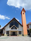 Cathedral of Saint Mary
 -
 Muladharma Buddhist temple
 -
 Thien Ie Kong temple


Samarinda Metropolitan Area
[edit]The urban area surrounding the city contains many suburban communities, particularly in the neighbouring districts (kecamatan) of Loa Kulu, Loa Janan, Muara Jawa, Sanga Sanga, Anggana and Muara Badak (all part of Kutai Kartanegara Regency). Together with the city's own residents, they constitute an urban area of over 1,050,000 inhabitants.
Education
[edit] Rectorate Building of Mulawarman University
Around 2010/2011, Samarinda has 252 elementary schools, 129 junior high schools, 54 senior high school, 53 vocational schools, and 27 colleges.[36]
Healthcare
[edit] Inche Abdoel Moeis Regional Public Hospital
Samarinda has sufficient healthcare facilities in East Kalimantan. They are also supported by several colleges associated with healthcare, one of those is Abdul Wahab Sjahranie Regional Public Hospital which is affiliated with Mulawarman University and East Kalimantan Healthcare Polytechnic.
Economy
[edit] Samarinda is East Kalimantan's largest container ports
Since 2004, trade has been the engine of Samarinda's economic growth.[37] It is also driven by the large amount of logging and oil extraction companies based there. Similar to Balikpapan, many national logging companies are based in Samarinda.[citation needed] There are many abandoned coal mines in Samarinda. Coal mining used to be very popular in Samarinda. However, the Indonesian government revoked many mining licenses due to the use of illegal chemicals and machinery.[citation needed]
Tourism sector also plays an important role in Samarinda's economy; it attracted over 2,000 international tourists and 1.2 million domestic tourists in 2019,[38] making Samarinda the 2nd most popular tourists destination in East Kalimantan.[39] In 2020, agriculture constituted only 2 per cent of GDP, and consists of growing flower varieties (rose, jasmine, orchid) and fruits (pomelo citrus fruit).[13]

Banking
[edit]As of 2024, there are 42 banks operated in Samarinda. The head office of Regional development bank, Bankaltimtara located in the city.
Commerce
[edit]Samarinda is home to several malls and traditional markets. Among them include Samarinda Morning Market, Segiri Market, Samarinda Central Plaza, Mal Lembuswana, and Big Mall Samarinda.
Tourism
[edit]Nature
[edit]There are natural tourist attractions such as Tanah Merah Waterfall, Berambai waterfall, Steling Selili Mountain, etc.
Culture
[edit]Budaya Pampang village is located around 20 km from the downtown. The village is known for its attraction by Kenyah people on Sunday.
Markets
[edit].jpg) Pasar Pagi, the oldest market in Samarinda
Pasar Pagi, the oldest market in Samarinda
There are 10 markets scattered in Samarinda. The oldest one is Pasar Pagi (Morning Market), which was built on the river bank. As the city grew, the market relocated away from the river. While Palaran Trade Centre (PTC) is the first market in Samarinda with a modern concept, the market was opened on 10 May 2010.
Transport
[edit]The main transport infrastructure of Samarinda is different than every other cities in Kalimantan, characterised by more dominant private companies and local government involvement compared to national government involvement. Those are Samarinda International Airport (East Kalimantan government),[40][41] SkyTrain rapid transit project (public-private partnership),[42][43] Samarinda Tunnel project (Samarinda Government)[44][45] and Port of Palaran (private).[46]
Water
[edit] Achmad Amins Bridge
As a city located on the Mahakam river, Samarinda has a history of water transportation. The notable transportation is Tambangan and Ketinting. Tambangan used to cross the river from Samarinda Seberang to Pasar Pagi, while Ketinting became the transportation to cross the river or to other places. Ferries used to operate from Harapan Baru, Samarinda Seberang to Samarinda city for transporting vehicles.
After the Mahakam Bridge was erected in 1986, the usage of Tambangan and Ketinting decreased though didn't significantly, and ferries ceased to exist.
Besides Mahakam Bridge, there are 3 other bridges such as Mahakam Ulu Bridge, Achmad Amins Bridge, and Mahakam IV Bridge.
 Container port in Palaran
The prominent coal loading port of Tanjung Bara (TBCT) lies about 160 kilometres to the north of Samarinda.[47]
There is also a container port located in Palaran operated since 2010, which is used to replace the older port. During the construction of the IKN, the port has been officially designated as National Vital Object since 2023.[48]
Land
[edit] Seberang Bus Terminus
There are about 850,000 vehicles registered in Samarinda, the highest number of vehicles of any city in East Kalimantan.[49] Samarinda has 3 bus terminals. There are:
- Sungai Kunjang Bus Terminus which served routes to Balikpapan, Kutai Kartanegara, and West Kutai.
- Lempake Bus Terminus which served routes to Bontang and East Kutai.
- Seberang Bus Terminus which served routes to Paser and South Kalimantan.[50]
 Toll gate at Palaran
Samarinda is connected by Trans-Kalimantan Highway Southern Route from Balikpapan to Samarinda; the highway runs in parallel with the first controlled-access expressway in Borneo, the Samarinda-Balikpapan Toll Road.[51] Samarinda also will be connected with Bontang through Samarinda-Bontang Toll Road, which is in construction and will be completed in 2026.
Air
[edit] Aerial view of Samarinda International Airport in 2018
APT Pranoto (Samarinda Sungai Siring, AAP) International Airport is the primary airport for the city and has been at Sungai Siring since 2018. With over 1 million passengers annually, it is one of East Kalimantan's busiest airports in terms of passenger and cargo movements. AAP is an important Australian passenger gateway for East Kalimantan's wildlife. AAP was built to replace Temindung Airport in Bandara, Sungai Pinang.
Sport
[edit] Palaran Stadium
Samarinda has sports facilities such as basketball courts, football fields, and rock climbing. Samarinda also has 3 stadiums, which are Gelora Kadri Oening Stadium, Segiri Stadium, and Palaran Stadium.
Samarinda is home to professional football club which competes in Super League, Borneo FC with Segiri Stadium as their ground.
Media
[edit]Television
[edit] TVRI East Kalimantan station
Currently there are only 2 local TV stations, which are TVRI East Kalimantan, and Tepian TV. There were also Samarinda TV and Samcom TV, both of which have ceased to broadcast.
Newspaper
[edit]The first newspapers in Samarinda were Persatoen and Perasaan Kita. Both were not daily newspapers. The first daily newspapers in Samarinda were Surat Kabar Pewarta Borneo and Pantjaran Berita.
During the New Order era, there were only 2 newspapers allowed in East Kalimantan. Manuntung (became known as Kaltim Post) and Suara Kaltim (before renamed to Swara Kaltim).[52]
The current newspapers are Samarinda Pos (which is a subsidiary of Kaltim Post Group), KoranKaltim, Kalpost, and Express.
Notable people
[edit]References
[edit]Citations
[edit]- ^ a b c d e f Badan Pusat Statistik, Jakarta, 28 February 2025, Kota Samarinda Dalam Angka 2025 (Katalog-BPS 1102001.6472)
- ^ "7 Kota Terbesar di Indonesia, Mana yang Paling Luas?". MSN. Archived from the original on 26 January 2023. Retrieved 26 January 2023.
- ^ "Puncak Samarinda, Kalimantan Timur Cocok Dijadikan Tempat Camping". Tribun Kaltim Travel. Archived from the original on 26 September 2021. Retrieved 26 September 2021.
- ^ "Indahnya Pesona Alam dari Puncak Samarinda". Klik Samarinda. 14 March 2021. Archived from the original on 26 September 2021. Retrieved 26 September 2021.
- ^ "Puncak Samarinda, Berkemah di Atas Awan". Traveling Yuk. 16 October 2019. Archived from the original on 20 January 2021. Retrieved 26 September 2021.
- ^ "Monografi Kalimantan Timur 1968". Government of East Kalimantan. 1969. Archived from the original on 26 January 2023. Retrieved 26 January 2023.
- ^ "Borneo". WorldAtlas. 20 August 2021. Archived from the original on 29 September 2021. Retrieved 26 January 2023.
- ^ "Masyarakat Indonesia 30-31". LIPI. 2004. Archived from the original on 26 January 2023. Retrieved 26 January 2023.
- ^ Data Sensus Penduduk 2010 - Badan Pusat Statistik Republik Indonesia <http://sp2010.bps.go.id/index.php/site/tabel?tid=321&wid=6400000000&lang=id>
- ^ "Pemindahan Pusat Pemerintahan kota Samarinda Tinggal Tunggu Walikota". Nomor Satu Kaltim. 13 April 2021. Archived from the original on 31 May 2022. Retrieved 31 May 2022.
- ^ "Tinggalkan Balikpapan, Samarinda Masuk dalam Jajaran Kota Layak Huni di Indonesia". Presisi. 12 June 2023. Archived from the original on 13 June 2023. Retrieved 13 June 2023.
- ^ "Samarinda Raih Top Tier City Indonesia". Natmed. 12 June 2023. Archived from the original on 13 June 2023. Retrieved 13 June 2023.
- ^ a b c "Samarinda in Figures 2021". BPS Samarinda. Archived from the original on 25 September 2021. Retrieved 25 September 2021.
- ^ a b Biro Pusat Statistik, Jakarta, 2011.
- ^ a b Badan Pusat Statistik, Jakarta, 2021.
- ^ "Ekspor Kalimantan Timur 2020". BPS East Borneo. Archived from the original on 25 September 2021. Retrieved 25 September 2021.
- ^ "Impor Kalimantan Timur 2020". BPS East Borneo. Archived from the original on 25 September 2021. Retrieved 25 September 2021.
- ^ "East Kalimantan in Figures 2021". BPS East Borneo. Archived from the original on 27 September 2021. Retrieved 25 September 2021.
- ^ "UU No. 27 Tahun 1959". peraturan.bpk.go.id. Retrieved 30 December 2024.
- ^ "UUDrt No. 3 Tahun 1953". peraturan.bpk.go.id. Retrieved 10 November 2024.
- ^ "BRS Kaltim December 2021". BPS East Borneo. Archived from the original on 2 February 2022. Retrieved 2 February 2022.
- ^ "Patimban Bakal Jadi Pelumas Samudera Indonesia (SMDR) & Temas (TMAS)". Bisnis. 16 October 2020. Archived from the original on 25 September 2021. Retrieved 25 September 2021.
- ^ "Kaltim Kariangau Terminal – Handal, Tepat Waktu dan Efisien". Retrieved 25 December 2021.
- ^ "Perhatikan 4 Hal Ini Saat Berburu Oleh-oleh Khas Samarinda". JalanTikus.
- ^ Dahlan, Oemar (1978). Asal-Usul Nama Samarinda Sejak Zaman sebelum Kemerdekaan, Nama Ini Sudah Terkenal di Seluruh Indonesia. Jakarta: Ministry of Education and Culture.
- ^ a b Ars, Moh (1986). Sejarah Kota Samarinda. Jakarta: Ministry of Education and Culture.
- ^ L, Klemen (1999–2000). "The conquest of Borneo Island, 1941-1942". Forgotten Campaign: The Dutch East Indies Campaign 1941-1942. Archived from the original on 11 November 2022. Retrieved 30 March 2021.
- ^ Sejarah Kota Samarinda (PDF). Departemen Pendidikan dan Kebudayaan — Proyek Penerbitan Buku Bacaan dan Sastra Indonesia dan Daerah. 1986.
- ^ "Hujan Es di Samarinda Seberang, Biasanya Terjadi di Awal Musim Hujan". Tribun News. 21 November 2019. Archived from the original on 28 September 2021. Retrieved 28 September 2021.
- ^ "Viral, Hujan Es Bikin Heboh Warga Samarinda". IDN Times. 21 November 2019. Archived from the original on 28 September 2021. Retrieved 28 September 2021.
- ^ "Samarinda Alami Fenomena Aphelion, Apa Itu?". Samarinda Post. 7 July 2021. Archived from the original on 28 September 2021. Retrieved 28 September 2021.
- ^ "BMKG Catat Suhu Terpanas di Indonesia, Wilayah di Kalimantan Catatkan Rekor Maksimum". kaltim.tribunnews.com. Retrieved 27 February 2024.
- ^ "TEMINDUNG, ID Climate: 1991–2020". Starlings Roost Weather. Retrieved 25 December 2024.
- ^ "Samarinda climate: Average Temperature, weather by month, Samarinda weather averages - Climate-Data.org". en.climate-data.org. Retrieved 25 December 2021.
- ^ "Badan Pusat Statistik". samarindakota.bps.go.id. Retrieved 6 June 2024.
- ^ "DAPODIK - Provinsi Kalimantan Timur". kaltim.dapodik.org. Archived from the original on 8 November 2010. Retrieved 26 November 2025.
- ^ "Samarinda in Figures 2005". BPS Samarinda. Archived from the original on 28 September 2021. Retrieved 28 September 2021.
- ^ "Samarinda in Figures 2020". BPS Samarinda. Archived from the original on 28 June 2021. Retrieved 26 September 2021.
- ^ "Orang Samarinda dan Bontang paling gemar berwisata, Derawan paling favorite". Niaga Asia. 20 November 2021. Archived from the original on 20 November 2021. Retrieved 20 November 2021.
- ^ "APT Pranoto, Perjuangan Kaltim Wujudkan Mimpi". Government of East Borneo. 2 December 2018. Retrieved 9 October 2021.
- ^ "Jokowi Pamerkan Bandara APT Pranoto, Dibangun Pakai APBD Pemprov Kaltim". Merdeka. 25 October 2018. Retrieved 9 October 2021.
- ^ "5 Proyek Infrastruktur Samarinda Melalui Sistem KPBU". G Priority. 7 October 2021. Retrieved 9 October 2021.
- ^ "Jadi Penyangga Ibu Kota Negara, Samarinda Diharapkan Bangun Infrastruktur Melalui KPBU". Headline Kaltim. 8 October 2021. Retrieved 9 October 2021.
- ^ "Groundbreaking Terowongan di Gunung Manggah, Walikota: Pertama di Indonesia yang Diinisiasi Pemerintah Daerah". Headline Kaltim. 20 January 2023. Archived from the original on 20 January 2023. Retrieved 20 January 2023.
- ^ "Upaya Pemkot Samarinda Bangun Terowongan Pemecah Kemacetan". Liputan 6, SCTV. 24 January 2023. Archived from the original on 24 January 2023. Retrieved 24 January 2023.
- ^ "About Us". Samudera Ports. Retrieved 9 October 2021.
- ^ Admiralty sailing directions - Indonesia (10th ed.). Taunton: UK Hydrographic office. 15 July 2015.
- ^ Media, Kompas Cyber (29 September 2023). "Naik Status, Pelabuhan Peti Kemas Palaran Samarinda Resmi Jadi Objek Vital Nasional". KOMPAS.com (in Indonesian). Archived from the original on 4 June 2024. Retrieved 26 November 2025.
- ^ "East Kalimantan in Figures, 2022". BPS East Kalimantan. Retrieved 31 May 2022.
- ^ "Terminal Bus, Samarinda". Government of East Kalimantan (in Indonesian). Retrieved 31 May 2022.
- ^ North Kalimantan Province Road Map Archived 29 April 2018 at the Wayback Machine - by the Road Preservation Directorate, Ministry of Public Works and Public Housing, Indonesia.
- ^ "Sekilas Sejarah Surat Kabar Harian di Kaltim Era Reformasi - Kaltim Ampunku". Kaltim Ampunku (in Indonesian). 4 December 2019. Archived from the original on 4 December 2019. Retrieved 26 November 2025.
Sources
[edit]- L, Klemen (1999–2000). "Forgotten Campaign: The Dutch East Indies Campaign 1941-1942".
External links
[edit] Definitions from Wiktionary
 Media from Commons
 News from Wikinews
 Quotations from Wikiquote
 Texts from Wikisource
 Textbooks from Wikibooks
 Resources from Wikiversity
 Travel information from Wikivoyage
 Data from Wikidata
- GovSamarinda Archived 15 May 2010 at the Wayback Machine Samarinda Government portal
Places adjacent to Samarinda | |
|---|---|
Regencies and cities of East Kalimantan | ||||
|---|---|---|---|---|
Capital: Samarinda | ||||
| Regencies |
| |||
| Cities | ||||
Articles Related to Samarinda | |||||||||||||||||||||||||||||||||||
|---|---|---|---|---|---|---|---|---|---|---|---|---|---|---|---|---|---|---|---|---|---|---|---|---|---|---|---|---|---|---|---|---|---|---|---|
| |||||||||||||||||||||||||||||||||||
| International | |
|---|---|
| National | |
| Geographic | |
| Other | |